


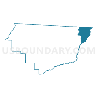
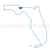
3-Voting District 3, Gadsden County, Florida
About
Outline

Summary
| Unique Area Identifier | 553374 |
| Name | 3-Voting District 3 |
| County | Gadsden County |
| State | Florida |
| Area (square miles) | 26.13 |
| Land Area (square miles) | 25.78 |
| Water Area (square miles) | 0.36 |
| % of Land Area | 98.64 |
| % of Water Area | 1.36 |
| Latitude of the Internal Point | 30.65362990 |
| Longtitude of the Internal Point | -84.34067650 |
Maps

Graphs
Select a template below for downloading or customizing gragh for 3-Voting District 3, Gadsden County, Florida


Neighbors
Neighoring Voting District (by Name) Neighboring Voting District on the Map
- 0871005 - BELL Voting District, Decatur County, GA
- 131D - DUNCANVILLE Voting District, Grady County, GA
- 131H - HIGDON Voting District, Grady County, GA
- 14A-Voting District 14, N Subprecinct A, Gadsden County, FL
- 20A-Voting District 20, N Subprecinct A, Gadsden County, FL
- 20B-Voting District 20B, Gadsden County, FL
- 2A-Voting District 2, Subprecinct A, Gadsden County, FL
- 3473-Voting District (Friendship AME Church), Leon County, FL
- 3477-Voting District (Betholonia AME Church), Leon County, FL
Top 10 Neighboring County Subdivision (by Population) Neighboring County Subdivision on the Map
- Northeast Leon CCD, Leon County, FL (51,481)
- Havana CCD, Gadsden County, FL (14,959)
- Attapulgus CCD, Decatur County, GA (2,365)
- Calvary-Reno CCD, Grady County, GA (1,682)
- Southeast Grady CCD, Grady County, GA (651)
Top 10 Neighboring Unified School District (by Population) Neighboring Unified School District on the Map
- Leon County School District, FL (275,487)
- Gadsden County School District, FL (46,389)
- Decatur County School District, GA (27,842)
- Grady County School District, GA (25,011)
Top 10 Neighboring State Legislative District Lower Chamber (by Population) Neighboring State Legislative District Lower Chamber on the Map
- State House District 8, FL (152,934)
- State House District 9, FL (147,197)
- State House District 172, GA (45,097)
Top 10 Neighboring State Legislative District Upper Chamber (by Population) Neighboring State Legislative District Upper Chamber on the Map
Top 10 Neighboring 111th Congressional District (by Population) Neighboring 111th Congressional District on the Map
Top 10 Neighboring Census Tract (by Population) Neighboring Census Tract on the Map
- Census Tract 201.02, Gadsden County, FL (6,121)
- Census Tract 201.01, Gadsden County, FL (4,802)
- Census Tract 23.02, Leon County, FL (3,342)
- Census Tract 9708, Decatur County, GA (2,365)
- Census Tract 9506, Grady County, GA (2,333)